Overview: Holdsworth Jumbo Circuit - Powell Hut for a night, then across the tops to Atiwhakatu Hut for night 2, via Jumbo. Out to the carpark on the last day.
Through some unusual twist of fate, the sun was shining through the treetops as we made our way up the Gentle Annie track to Powell Hut. After about an hour we'd reached rocky lookout, where we stopped for lunch.


From rocky lookout, the track winds its way further up the hillside, eventually reaching a junction some 4.9km from the start of the track. The left fork descends to Totara Flats, while we continued up the other track. The track then crosses the aptly-named Pig Flat (aptly named for the flat part, couldn't comment on the pigs), meandering through stunted trees and over boardwalks, soon reaching Mountain House Shelter.


From Mountain House, the track steepens, gaining almost 500m in altitude over 2km.


We reached the hut after 4 hours & 20 mins, alongside 7 others. Thankfully, almost no one else had arrived so we could claim some prime bunk real estate. This worked out well, as the hut was at capacity by nightfall.

The next morning brought more clear skies and a beautiful morning over the Wairarapa.


We set off at 10am, making our way through the tussocks up toward Mt Holdsworth. The peak is about 1.8km from hut with an altitude of 1470m, placing it just shy of the 15 peaks over 1500m, and 101m shorter than Mitre - the highest peak in the Tararuas.
How long it takes to reach the peak varies wildly on how often one stops to take photos and the like, in this case taking us just over an hour. A slow time, certainly, but given we had all day to reach Atiwhakatu Hut it is - to my mind - well worth dawdling over the tops, soaking in the views and generally having a good time.


 |
| High Ridge, with the snow-capped peaks of Hector and its neighbours in the backround Also visible behind high ridge are the peaks of Aokaparangi and Maungahuka. |


 |
| Holdsworth trig, with the cluster of peaks around Angle Knob and McGregor in the backgrund. |
 |
| View along the ridge to Jumbo. Angle Knob, McGregor and the Three Kings are some of the snow capped peaks in the back. |
On a clear day, such as that we were lucky enough to get, views to the east extend to the Wairarapa coast, and west to Kapiti Island. Major ridges and peaks of the Tararuas are visible to the the North, South and West. At a stretch, the Aorangi Range and the top of the South Island are also visible.
After spending a sufficiently long time to take this all in, we started making our way along the ridgeline to Jumbo, reaching the East Holdsworth Spur turn-off after about 25 minutes.


 |
| Sign at the East Holdsworth track turn-off. |

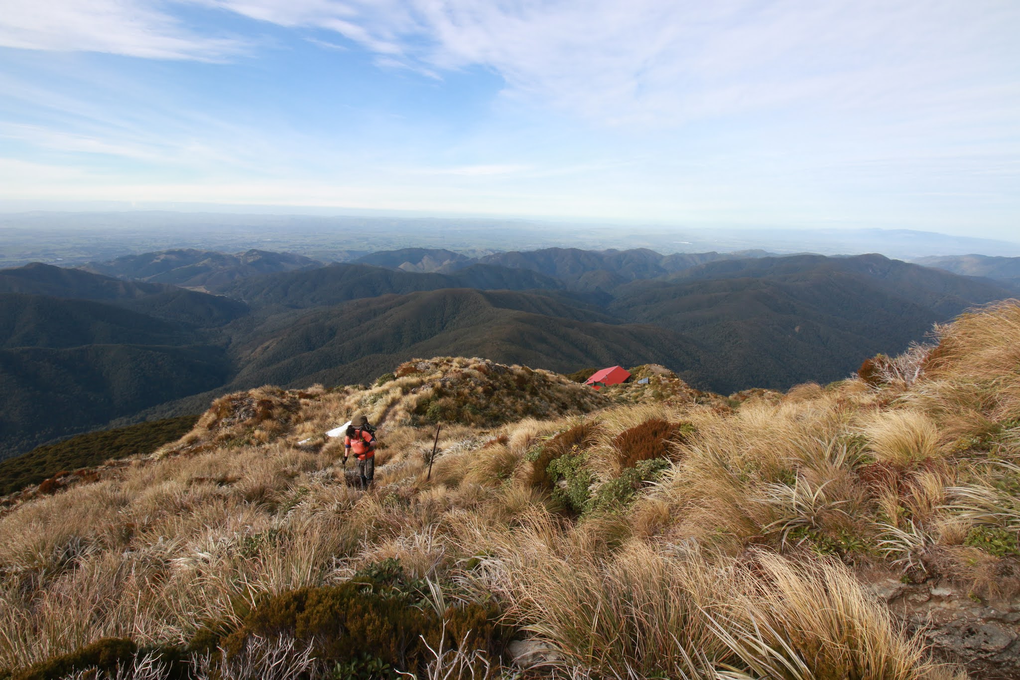
For somewhere that may appear as a featureless, tussocky wasteland, there's a surpising amount of variability in the environs. The track at times is a narrow foot trail through a broad patch of identical tussocks, other times on of many meandering lines of scree down a slope, or a rocky sidle, or a muddy divet between a couple of higher outcrops. Always accompanied (at least when the weather is clear) by spectacular 360 degree views.


The ridge becomes noticeably rockier and narrower as Jumbo is reached, with the odd brief clamber required shortly before reaching the peak. By this point, it had taken us about 4 hours to cover the almost 5km from Powell Hut, owing to our indulgent pace.
Jumbo (1405m) affords excellent views of some of the highest peaks in the range - Angle Knob (1510m), McGregor (1540m), and the Three Kings (1531m, 1521m & 1535m), as well as the Broken Axe Pinnacles. Mostly obscured is Mitre.
From Jumbo, the track follows a narrow, rocky ridge to the east, eventually broadening and dropping down to Jumbo Hut.


Some 45-ish minutes from the beak, we arrived at Jumbo Hut, where we took the opportunity for another break before the dreaded descent down rain gauge spur.


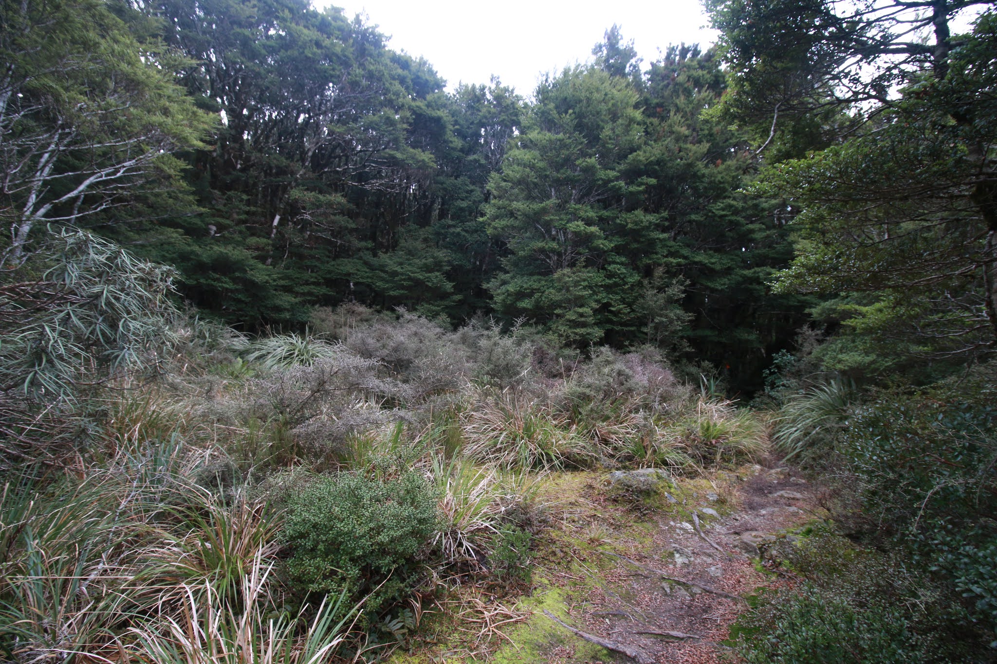


Below Jumbo Hut, the track quickly enters a mossy forest of stunted, twisted beech. Even as the altitude lessens and the trees straighten, the thick moss and lush undergrowth lend the spur an almost mystical feel. "Trees are trees," you might be tempted to think, yet both Cody and myself both noted how markedly different this spur seemed, compared to the track up Mt Holdsworth, a short distance to the south.
The tracks drops rapidly from 1200m at Jumbo Hut to 480m at Atiwhakatu over its 2.6km length. Frequently knee-crunchingly steep, and containing an abundance of homicidal tree roots and loose detritus, the descent is slow.
Atiwhakatu Hut is visible through the trees a few minutes before it's reached, at which point it's a very welcome sight. I had a thought about then, that perhaps the best level of difficulty for a tramp is the level that's just enough to make a hard bench seat and a packet of dehy at the end of the day seem like the best things in the world. It was just about 5pm by the time we reached the hut.
Being a Sunday, it was unsurprising when we found ourselves the sole occupants of the hut for the night., which was a nice change from Powell the night before.
The next morning we departed at 10:20, thankful for the flat, well-maintained nature of today.s track. I've described this track in detail before so I won't bother doing so again. Instead, here's some photos:


1 hour & 50 mins later we were back in the carpark, the 6.8km from Atiwhakatu passing in well-graded ease. The only thing of note along the way was that at the large slip about 2.4km from the hut, the track has been diverted again, now crossing along the bottom of the slip. Looks like some of it's current path follows a previous alignment, given the presence of old retaining boards and the like. Presumably the slip has stabilised enough at the bottom that it's no longer worth continually re-routing the track higher and higher every time it moves at the top.
Slip diversion aside (pun intended), another brilliant excursion across the Holdsworth-Jumbo. Not much more to say than that really.
Map:

Trip data:
Day 1 - Holdsworth carpark to Powell Hut: 8.24km, 4hours 21mins.
Day 2 - Powell Hut to Mt Holdsworth: 1.8km, ~1 hour. Mt Holdsworth to Jumbo Hut: 4.24km, ~4 hours. Jumbo Hut to Atiwhakatu Hut: 2.42km, ~2 hours. Total: 8.46km, 6:57 (Could readily be done much faster).
Day 3: Atiwhakatu Hut to Carpark: 6.78km, 1:50.
Note: distances are from GPS data imported to Memory-Map. Recorded distances were higher on GPS track log. Something about measurement intervals, jitter, and interpolation errors with software vs. GPS unit.
Elevation Profiles:

Vaguely Dangerous Wilderness