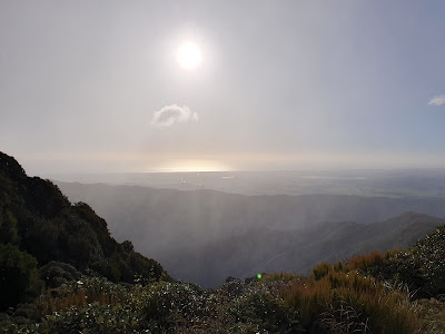
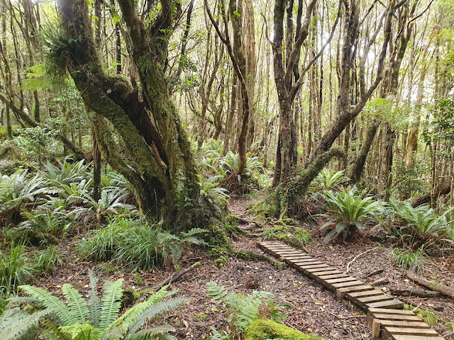
Spectacular views await at the end of this tramp up a near-endless ridge.
The track begins over squidgy farmland from the small carpark at the end of Poads Road, a short distance from Levin. Part way through the waterlogged paddocks, a large boulder with a memorial plaque slapped on it is passed.
15 minutes later, the Tararua Forest Park is reached and the track branches in two directions (well signposted). Straight ahead will take you to the Ohau River gorge (a track that's officially closed currently due to a slip). Turning right, the ascent up to the Waiopehu Ridge begins immediately.
 |
| Boulder |
The next 2.5km are the steepest and most challenging part of the journey. The track is also quite slippery in places. 3.5km/1hr30 from the start, a second track junction is reached. I breathed a sigh of relief at this point, and promptly sat myself on a conveniently placed fallen tree to have snack and catch my breath before beginning what would turn out to be a seemingly endless trudge along the ridge.
 |
| Rata? |
At this junction, the left branch is the bemusingly named Six Discs track, which descends to meet the aforementioned Ohau Gorge track. Again take the right branch: the Waiopehu track along the Waiopehu Ridge to Waiopehu Hut and also Waiopehu Peak (how many times can I reasonably include the word 'Waiopehu' in sentence?).
Whilst another 500m or so of altitude is gained from this point, it's a climb that is largely spread out across the length of the ridge so the gradient is relatively tolerable. The track is quite muddy in places, although work to install wooden 'rafts' (a sort of basic boardwalk) is being carried out by the Levin-Waiopehu Tramping Club.
The ridge is entirely below the bushline, so views are few-and-far between and it can begin to get a bit tedious. Though to call it unpleasant would be unfair.
About 1km from the hut, the site of the previous incarnation of Waiopehu Hut is approached through a small clearing. An almost illegibly faded sign marks the old huts location. A concrete slab from the open fireplace is all that remains.
The track gets a little steeper along these final stretches, but I reached the hut in a time I found surprisingly quick after the temporal quagmire of the preceding ridge section.
As the bushline is approached and the trees become shorter, views begin to open up. At this point, brief periods of an almost sleety drizzle wafted over, but cloud never set in and the rain combined with sun to create a striking rainbow sitting in front of the inner ridges of the Tararua Range.
The hut sits near the edge of the ridge, bathed in afternoon sun. Signposts point the way to the main entrance, toilet, and hose for washing mud off boots. All told, 4hr39min had elapsed by the time I reached the hut.
The interior of the hut is spacious and warm from the sun. Two semi-separated sleeping areas are at one end, with the cooking/dining area at the northern end. Windows allow views to the west and north across the Horowhenua and Manawatu plains.
Sunset brought more incredible views, both out toward the sea and deeper into the ranges.
Despite the freezing cold temperatures outside, the well-insulated hut remained surprisingly not-cold (although not quite warm) despite a lack of heating.
The next morning brought cloud and the thought that the toilet here might challenge Powell Hut for loo with best view in the Tararua FP (the toilets themselves at Powell are undoubtedly better however).
Following porridge and coffee, I decided to take a quick side-trip up to the nearby Waiopehu peak (1094m) after hearing from some other hut occupants that views from there are even better.
The track initially climbs steeply from the hut through a small patch of beech trees before emerging onto the tops and sidling next to the peak itself. From there, the track dips onto a muddy ridge before eventually climbing again up to Twin Peak (1097m). The track here is very slippery and a small nub between the two main peaks briefly got my hopes up that the twin peak was much closer than it actually is.
 |
| Dracophyllum in the mist |
 |
| Ralph Wood memorial cross |
 |
| Trig with 2nd Ralph Wood cross |
There's a trig station and memorial cross on twin peak, and it's pretty much exactly 1km from the hut. Alas the cloud prevented any of the foretold views, but it was a worthy enough diversion.
By the time I returned to the hut to grab my pack, the low cloud was starting to burn of and I considered that had I left for the peaks now, I would most likely have seen the views. Ah well, a good excuse to come back I suppose.
The return walk is quite a bit quicker than coming in, and passed by uneventfully with the exception of multiple near-falls and one surprisingly graceful slide onto my rump.
 |
| Funky tree hole |
 |
| Boulder |
I made good time, reaching the carpark about 3hr40 after leaving the hut.
Times & Distances
Carpark to Forest Park boundary/Ohau Gorge junction: 1.10km, 14 min
FP boundary to Six Discs junction: 2.47km, 1 hr 14 min
Six Discs to Waiopehu Hut: 6.63km, 3 hr 11 min.
Total: 10.2 km, 4:39.
Waiopehu Hut to Peak: 480m, to Twin Peak: 1 km (2.01 km return trip).
Waiopehu Hut to Six Discs junction: 6.63km, 2 hr 23 min
Six Discs to Carpark: 3.47km, 1 hr 12 min.
Total: 10.2 km, 3:35 (12.21km including side trip to peaks).


